8 Days Skiing In Rwenzori Mountain Through the Kilembe Trail.
8 Days Skiing In Rwenzori Mountain Through the Kilembe Trail: The kilembe trail will take you for 8 days of ski adventure in Rwenzori mountains on the Stanley and margherita glaciers in Rwenzori. Your trip will start from kilembe gate of Rwenzori mountains national park.
Skiing in mount Rwenzori is well arranged with the Rwenzori Mountain experts like Bujuku Eco Tours & Travel who understands the mountain very well, the best months to hike and the trails.
Skiing in Rwenzori mountains is done by experienced skiers and you need to book in time in order to plan the best for skiing in Rwenzori glaciers. Rwenzori glaciers are declining due to global warming, make sure to book your ski experience in Rwenzori before the glaciers recede completely.
The Rwenzori glaciers have been in existence for many years now but they keep reducing in size every decade.
Day 1. Trek from kilembe gate (1450m) to sine hut (2596m)
Your trek will start by walking up the valley floor through tall forest trees of the Afro Montane Forest Zone. This is a steady climb with crowds of birds and a chance of seeing blue monkeys darting off through the forest. At times visitors may see troupes of 15 to 20 black and white Colobus monkeys as they swing through the tree tops. There are rare sightings of the L’Hoest monkey which are part of the Bakonzo cultural emblems and are protected by the virtue of the King or Omusinga. You may also hear wild chimpanzee in the distance. There are a wide variety of plant species from forest trees to bamboos thickets, low shrubs, flowers, fungi, and with many mosses and lichen covered vines hanging from the tall trees creating an awesome appeal. Enock’s Falls are just 200 meters from Sine Hut and offer a splendid opportunity to capture a great picture for your memories.
Dinner and overnight
Day 2. From Sine Hut (2,596m) Ascend to Kalalama Camp (3,134m) and Proceed to Mutinda Camp (3588m)
Trekking starts at 8.30am and almost immediately you enter the Bamboo-Mimulopsis Zone which is a steep ascent with many high steps. In the wet season the bamboo zone is rather muddy and slippery making the going slow. However, the atmosphere and the forest is beautiful as you climb 551 meters altitude and a distance of 1.8km to Kalalama Camp at 3,134 meters which is in the Heather-Rapanea Zone where you can take a rest and a quick cup of tea or coffee before heading on to Mutinda Camp. The trail strolls up and over several small hills along a ridge top then drops down the side of the valley before climbing again, and in doing so cross several small streams and pass close to moss covered waterfalls. You then climb steadily along the side of a beautiful mossy river which tumbles down over the rocks under the Giant Heather trees whose trunks are covered in green moss with old man beards (Usnea lichen) hanging from the branches. The trail twists and turns as you climb up the deep valley, which has an enormous variety of plants and flowers. This valley is unique with many Giant Heather trees creating a beautiful atmosphere often shrouded in mist.
In the afternoon you may wish to climb up to the top of the Mutinda Lookout (one to two hours up and one hour down) The views are amazing as you stand on moss covered rocks at 3,925 meters with views across the Rwenzori Mountains and down to Kasese town and Lake George. For those clients who are summitting to Margherita or any of the main peaks, climbing the Mutinda lookout is also an excellent way to acclimatise and reduce the risk of high-altitude sickness
Dinner and overnight at Mutinda Camp
Day 3. Mutinda camp (3588m) to Bugata camp (4100m)
The trail to Bugata Camp is boggy mainly in the wet season but with a little skill you can step from clump to clump to make the going easier. First you cross the Mutinda valley through the tussock grass and everlasting flowers scattered with many Giant Lobelias before climbing a steep section up to the Namusangi Valley (3,840m), with pure waterfalls and looking back you get fantastic views of Mutinda Peaks. The Namusangi Valley is wide, with many ups and downs as the trail climbs steadily to Bugata Camp at 4,100 meters.
Day 4. From Bugata camp (4100m) ascend to Hunwicks Camp (3974m)
Trek to Hunwick’s Camp via Bamwanjarra Pass. As you leave Bugata Camp you pass up a ridge then drop down slightly before ascending to Bamwanjarra Pass at 4,450 meters where there is a hut incase the weather turns bad. From the pass on a clear day, you get excellent views of the three main peaks. The trail passes down the valley and around the edge of some bogs and thick ever green vegetation, moss, giant groundsel and lobelia. This place is possibly one of the best places in all the Rwenzori to observe the Malachite Sunbird as it feeds on the many lobelia flowers and is a known breeding site. Further on there is some steep sections before a steady climb up and over the edge to Hunwick’s Camp which is located at the top of a deep valley and has good views of Mt Stanley, Mt Baker, Weismann’s Peak and McConnell’s Point.
Day 5. From Hunwick’s camp (4450m) to margherita camp (4485m)
From Hunwick’s you will pass down and across the valley floor to Lake Kitandara which is very stunning with deep water and beautiful vegetation. From here you climb up Scott Elliott’s pass then up the edge to Margherita Camp 4,485 metres which is situated between some huge rocks and offering some shelter from the strong winds. This is the very spot where the Duke of Abruzzi camped when making his climb to Margherita Peak in 1906.
Please note:
On this day you have an option of summitting Mt Baker if you are feeling fit. Baker is a short but tough climb but well worth all the effort especially on a clear day as you get excellent views of Mt Stanley, Margherita Peak and the Glaciers.
Day 6. Margherita Camp (4485m) Summit the Margherita Peak (5109m)
Wake up at 2am and have your early breakfast before heading off to ascend Mt Stanley at 2.30am. This is necessary as the weather has changed a lot and often even during the dryer season the mountain is closed in with heavy clouds and snow falls from 1 pm to 4pm and this happens within a short period of 10 to 15 minutes as the clouds rise up from the extensive Congo rainforests. During January and February 2017 clients were closed in and unable to walk during heavy snow storms which previously were not heard of during the dryer season and arrived back at Margherita camp well after dark with one group arriving back at 11pm totally exhausted.
Due to this change in weather, we have set a strict turn around time of 10am so if you do not reach the peak before then you must turn around regardless of the disappointment for the interests of safety. Margherita glacier has also suffered with global warming and as the outer edges of the glacier recede the ice is becoming steeper with one section of about 200 meters.
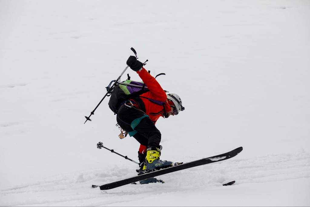
After ascending the peak at 5,109 metres you then descend back to start a ski session before going directly down to Hunwick’s Camp at 3.874 metres.
Day 7. From margherita camp (4485m) descend to kiharo camp
Distance to Kiharo Camp 11km Time taken to walk 4 to 7 hours
From Hunwick’s Camp we start the day by climbing up a ridge towards McConnell’s Prong where you get the best views of all three peaks and Scott Elliott’s Pass before reaching Oliver’s Pass at 4,505 metres. The distance from Hunwick’s Camp to the top of Olivers Pass is 3km, the trail then cuts across below Weismann’s Peak to the confluence of the Nyamwamba River which flows down through Kilembe and Kasese to Lake George in Queen Elisabeth National Park.
If you wish to climb Weismanns Peak 4,620 metres from Olivers pass you may do so at an extra cost of $20 each. On a clear day you get fantastic views of Margherita and Mt Stanley, Mt Speke and Mt Baker.
After crossing the confluence, the trail meanders down the valley to Kiharo Camp at which is situated in a deep valley with high cliffs and dense vegetation. On the way down the valley after each bog you will climb over a ridge of stones and earth which seems out of place but actually was pushed there by slow moving glaciers which eventually stopped moving, melted and left a pile of rocks and debris in front of where the glacier once stood.
Day 8. Kiharo Camp to Kilembe Gate (1450m)
The Distance from Kiharo Camp to the park gate is 16km. The time taken to walk is 5 to 8 hours so those who need to connect to flights back to Kampala or travel to other activities need to leave Kiharo early.
From Kiharo camp, the path turns off to the right pass along the river. Spot Duikers as you pass along the river otherwise trek down the river itself jumping across the rocks as you pass down.
The trail becomes steep with many of waterfalls after a few kilometres down the river, which is why you will have to move away from the river and follow a narrow ridge to bypass steep sections.
You will again meet the river where there are a huge rock shelter and a place to rest for a lunch break, after which, you will cross a small stream as you climb up gentle slopes before turning back down to the river to avoid another set of waterfalls which are impassable. The forest along this section is a home to many bird species, primates, duikers and hyrax. Descend to the base marking the end of the Kilembe trail Rwenzori Mountains trekking.
Activities
Skiing
Summiting the margherita peak
Hiking the Rwenzori mountains